Trail Walking La Chailleuse - St Laurent Bois de La Chailleuse - Photo

St Laurent Bois de La Chailleuse

 drarep
drarep

User

© OpenStreetMap contributors
Length
Length
13.3 km
Max alt
Max alt
583 m
Uphill gradient
Uphill gradient
337 m
Km-Effort
Km-Effort  
17.8 km
Min alt
Min alt
446 m
Downhill gradient
Downhill gradient
336 m
Boucle
Boucle
Yes
Creation date :
2017-01-26 00:00:00.0
Updated on :
2018-11-01 17:28:03.663

(0 Reviews)

Walking
Walking
3h43
Difficulty : Easy

Scan this QR Code to open this trail in the SityTrail application

FREE GPS app for hiking

Logo SityTrail SityTrail

IGN / Geographical institutes

Download SityTrail from the App Store Download SityTrail from Google Play

Logo SityTrail SityTrail Plus

The world is yours!

Download SityTrail from the App Store Download SityTrail from Google Play Download SityTrail on Huawei AppGallery

About

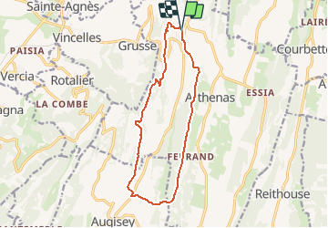
Trail Walking of 13.3 km to be discovered at Bourgogne-Franche-Comté, Jura, La Chailleuse. This trail is proposed by drarep.

Description

Départ de la salle des fêtes de Saint Laurent La Roche prendre la direction d'Arthenas par le bois de la Chailleuse etles Rippes d'Arthenas jusqu'à la Grange Rabillot. Traverser la D117 au nord d'Augisey pour remonter sur La Grange en Cey par la base d'envole des ailes Delta et retour sur Saint Laurent la Roche.
Pour les plus courageux il est possible de monter à la madonne

Elevation profile

Positioning

Country:
France
Region :
Bourgogne-Franche-Comté
Department/Province :
Jura
Municipality :
La Chailleuse
Location:
Saint-Laurent-la-Roche
Start:(UTM)
692927 ; 5164042 (31T) N.


Close
My subscriptions